Cross Country & Nav Log Quiz PPL
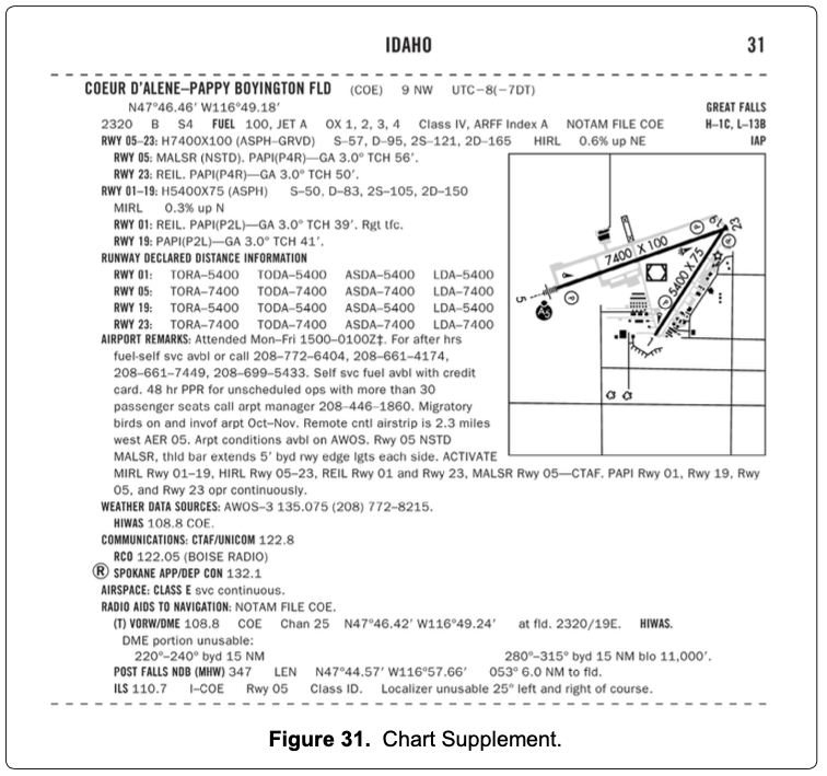
(Refer to figure 22, area 2; and figure 31.) At Coeur D'Alene, which frequency should be used as a Common Traffic Advisory Frequency (CTAF) to self-announce position and intentions?
122.05 MHz.
122.1/108.8 MHz.
122.8 MHz.
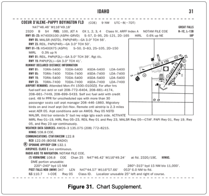
(Refer to figure 22, area 2; and figure 31.) At Coeur D'Alene, which frequency should be used as a Common Traffic Advisory Frequency (CTAF) to monitor airport traffic?
122.05 MHz.
135.075 MHz.
122.8 MHz.

(Refer to figure 22, area 2; and figure 31.) What is the correct UNICOM frequency to be used at Coeur D'Alene to request fuel?
135.075 MHz.
122.1/108.8 MHz.
122.8 MHz.
(Refer to Figure 20, area 3.) Determine the approximate latitude and longitude of Currituck County Airport.
36°24'N - 76°01'W.
36°48'N - 76°01'W.
47°24'N - 75°58'W.
(Refer to Figure 21, area 2.) Which airport is located at approximately 47°34'30"N latitude and 100°44'00"W longitude?
Turtle Lake.
Makeeff.
Johnson.
(Refer to Figure 21, area 3.) Which airport is located at approximately 47°21'N latitude and 101°01'W longitude?
Underwood.
Evenson.
Washburn.
(Refer to Figure 22, area 3.) Determine the approximate latitude and longitude of Shoshone County Airport.
47°02'N - 116°11'W.
47°33'N - 116°11'W.
47°32'N - 116°41'W.
(Refer to Figure 26, area 2.) What is the approximate latitude and longitude of Cooperstown Airport?
47°25'N - 98°06'W.
47°25'N - 99°54'W.
47°55'N - 98°06'W.
(Refer to Figure 27.) An aircraft departs an airport in the eastern daylight time zone at 0945 EDT for a 2-hour flight to an airport located in the central daylight time zone. The landing should be at what coordinated universal time?
1345Z.
1445Z.
1545Z.
(Refer to Figure 27.) An aircraft departs an airport in the central standard time zone at 0930 CST for a 2-hour flight to an airport located in the mountain standard time zone. The landing should be at what time?
0930 MST.
1030 MST.
1130 MST.
(Refer to Figure 27.) An aircraft departs an airport in the central standard time zone at 0845 CST for a 2-hour flight to an airport located in the mountain standard time zone. The landing should be at what coordinated universal time?
1345Z.
1445Z.
1645Z.
(Refer to Figure 27.) An aircraft departs an airport in the mountain standard time zone at 1615 MST for a 2-hour 15-minute flight to an airport located in the Pacific standard time zone. The estimated time of arrival at the destination airport should be:
1630 PST.
1730 PST.
1830 PST.
(Refer to Figure 27.) An aircraft departs an airport in the Pacific standard time zone at 1030 PST for a 4-hour flight to an airport located in the central standard time zone. The landing should be at what coordinated universal time?
2030Z.
2130Z.
2230Z.
(Refer to Figure 27.) An aircraft departs an airport in the mountain standard time zone at 1515 MST for a 2-hour 30-minute flight to an airport located in the Pacific standard time zone. What is the estimated time of arrival at the destination airport?
1645 PST.
1745 PST.
1845 PST.
Which statement about longitude and latitude is true?
Lines of longitude are parallel to the Equator.
Lines of longitude cross the Equator at right angles.
The 0° line of latitude passes through Greenwich, England.
How far will an aircraft travel in 7.5 minutes with a groundspeed of 114 knots?
14.25 NM.
15.00 NM.
14.50 NM.
(Refer to Figure 20.) En route to First Flight Airport (area 5), your flight passes over Hampton Roads Airport (area 2) at 1456 and then over Chesapeake Regional at 1501. At what time should your flight arrive at First Flight?
1516.
1521.
1529.
(Refer to Figure 20.) Determine the magnetic course from First Flight Airport (area 5) to Hampton Roads Airport (area 2).
141°.
321°.
332°.
(Refer to Figure 21.) What is the estimated time en route from Mercer County Regional Airport (area 3) to Minot International (area 1)? The wind is from 330° at 25 knots and the true airspeed is 100 knots. Add 3-1/2 minutes for departure and climb-out.
44 minutes.
48 minutes.
52 minutes.
(Refer to Figure 21.) Determine the magnetic heading for a flight from Mercer County Regional Airport (area 3) to Minot International (area 1). The wind is from 330° at 25 knots, the true airspeed is 100 knots, and the magnetic variation is 10° east.
002°.
012°.
352°.
(Refer to Figure 22.) What is the estimated time en route from Sandpoint Airport (area 1) to St. Maries Airport (area 4)? The wind is from 215° at 25 knots, and the true airspeed is 125 knots.
38 minutes.
30 minutes.
34 minutes.
(Refer to Figure 22.) Determine the estimated time en route for a flight from Priest River Airport (area 1) to Shoshone County Airport (area 3). The wind is from 030 at 12 knots and the true airspeed is 95 knots. Add 2 minutes for climb-out.
27 minutes.
29 minutes.
31 minutes.
(Refer to Figure 22.) What is the estimated time en route for a flight from St. Maries Airport (area 4) to Priest River Airport (area 1)? The wind is from 300° at 14 knots and the true airspeed is 90 knots. Add 3 minutes for climb-out.
38 minutes.
43 minutes.
48 minutes.
(Refer to Figure 22.) Determine the magnetic heading for a flight from Sandpoint Airport (area 1) to St. Maries Airport (area 4). The wind is from 215° at 25 knots and the true airspeed is 125 knots.
352°.
172°.
187°.
(Refer to Figure 22.) What is the magnetic heading for a flight from Priest River Airport (area 1) to Shoshone County Airport (area 3)? The wind is from 030° at 12 knots and the true airspeed is 95 knots.
121°.
143°.
136°.
(Refer to Figure 22.) Determine the magnetic heading for a flight from St. Maries Airport (area 4) to Priest River Airport (area 1). The wind is from 340° at 10 knots, and the true airspeed is 90 knots.
329°.
320°.
345°.
(Refer to Figure 23.) What is the estimated time en route for a flight from Allendale County Airport (area 1) to Claxton-Evans County Airport (area 2)? The wind is from 100° at 18 knots and the true airspeed is 115 knots. Add 2 minutes for climb-out.
33 minutes.
30 minutes.
27 minutes.
(Refer to Figure 23.) What is the estimated time en route for a flight from Claxton-Evans County Airport (area 2) to Hampton Varnville Airport (area 1)? The wind is from 290° at 18 knots and the true airspeed is 85 knots. Add 2 minutes for climb-out.
35 minutes.
39 minutes.
44 minutes.
(Refer to Figure 23.) Determine the magnetic heading for a flight from Allendale County Airport (area 1) to Claxton-Evans County Airport (area 2). The wind is from 090° at 16 knots, and the true airspeed is 90 knots. Use 5° west variation.
212°.
230°.
208°.
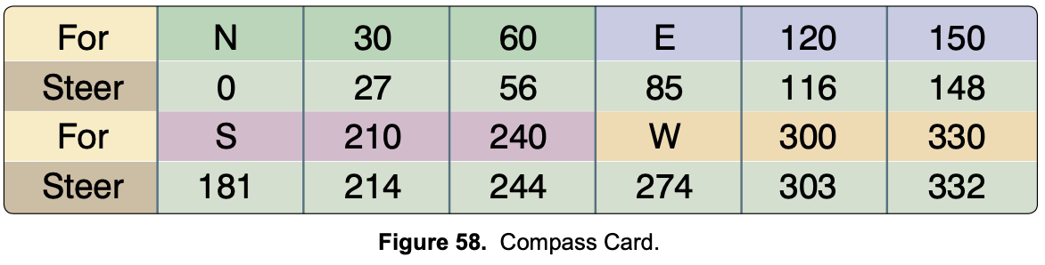
(Refer to Figures 23 and 58.) Determine the compass heading for a flight from Claxton-Evans County Airport (area 2) to Hampton Varnville Airport (area 1). The wind is from 280° at 08 knots, and the true airspeed is 85 knots. Use 6° west variation.
043°.
033°.
038°.
(Refer to Figure 23.) While en route on Victor 185, a flight crosses the 248° radial of Allendale VOR at 0953 and then crosses the 216° radial of Allendale VOR at 1000. What is the estimated time of arrival at Savannah VORTAC?
1023.
1036.
1028.
(Refer to Figure 24.) Determine the magnetic course from Airpark East Airport (area 1) to Winnsboro Airport (area 2). Magnetic variation is 6°30'E.
075°.
082°.
091°.
(Refer to Figure 25.) What is the estimated time en route for a flight from Denton Muni (area 1) to Addison (area 2)? The wind is from 200° at 20 knots, the true airspeed is 110 knots, and the magnetic variation is 7° east.
13 minutes.
16 minutes.
19 minutes.
(Refer to Figure 25.) Estimate the time en route from Addison (area 2) to Dallas Executive (area 3). The wind is from 300° at 15 knots, the true airspeed is 120 knots, and the magnetic variation is 7° east.
8 minutes.
11 minutes.
14 minutes.
(Refer to Figure 25.) Determine the magnetic heading for a flight from Fort Worth Meacham (area 4) to Denton Muni (area 1). The wind is from 330° at 25 knots, the true airspeed is 110 knots, and the magnetic variation is 7° east.
003°.
017°.
023°.
(Refer to Figure 26.) Determine the magnetic course from Cooperstown Airport (area 2) to Jamestown Airport (area 4).
028°.
222°.
208°.
The angular difference between true north and magnetic north is:
magnetic deviation.
magnetic variation.
compass acceleration error.
If a true heading of 135° results in a ground track of 130° and a true airspeed of 135 knots results in a groundspeed of 140 knots, the wind would be from:
019° and 12 knots.
200° and 13 knots.
246° and 13 knots.
When converting from true course to magnetic heading, a pilot should:
subtract easterly variation and right wind correction angle.
add westerly variation and subtract left wind correction angle.
subtract westerly variation and add right wind correction angle.
How far will an aircraft travel in 2-1/2 minutes with a groundspeed of 98 knots?
2.45 NM.
3.35 NM.
4.08 NM.
On a cross-country flight, point A is crossed at 1500 hours and the plan is to reach point B at 1530 hours. Use the following information to determine the indicated airspeed required to reach point B on schedule.
Distance between A and B: 70 NM
Forecast wind: 310° at 15 kts
Pressure altitude: 8,000 ft
Ambient temperature: -10 °C
True course: 270°
The required indicated airspeed would be approximately:
126 knots.
137 knots.
152 knots.
On the calculator side of the flight computer, distance in miles is always found on which scale?
Outer.
Inner.
Far inner.
On the calculator side of the flight computer, time is always found on which scale(s)?
Outer.
Inner scale only.
Inner scale and far inner scale.
How fast are you flying if you travel 2 miles in 1 minute?
30 miles per hour.
60 miles per hour.
120 miles per hour.
How fast are you flying if you travel 3 miles in 2 minutes?
60 miles per hour.
90 miles per hour.
12 miles per hour.
How long will it take you to fly 300 miles at 120 miles per hour?
15 minutes.
150 minutes.
230 minutes.
How far will you travel if you fly at 100 miles per hour for 2 hours and 30 minutes?
150 miles.
230 miles.
250 miles.
How fast are you flying if you travel 18 miles in 8 minutes?
60 miles per hour.
135 miles per hour.
180 miles per hour.
How far will you travel if you fly at 110 miles per hour for 11 minutes?
20 miles.
33 miles.
200 miles.
A basic rule to remember when using the calculator side of the flight computer is:
wind correction angle goes first.
that on the outer scale, 10 always represents 10 miles.
how fast goes first.
A basic rule to remember when using the calculator side of the flight computer is:
miles are always on the inner scale.
minutes are always on the outer scale.
"does the answer make sense?"
If you are using fuel at the rate of 8 gallons per hour, how many gallons will you use in 3 hours and 30 minutes?
21 gallons.
28 gallons.
33 gallons.
How many gallons per hour are you using if you use 36 gallons in 4 hours and 30 minutes?
8 gallons per hour.
9 gallons per hour.
27 gallons per hour.
When using a navigation plotter, it is important to note that:
zero miles is not at the physical end of the plotter.
shrinkage of the plastic is not possible.
the Sectional scale and the WAC scale are on the same side of the plotter.
Typical scales on the navigation plotter are:
miles per hour and kilometers per hour.
nautical and stationary.
Sectional and WAC.
True course is:
the direction the nose is pointed.
course referenced to true north.
the speed of the aircraft through the air.
Magnetic course is:
course referenced to lines of latitude and longitude.
the direction the nose is pointed referenced to magnetic north.
course referenced to magnetic north.
Magnetic heading is:
the number you want to see in the glass of the compass to fly where you want to go.
the direction the nose is pointed referenced to magnetic north.
the error in the compass due to magnetic fields in the aircraft.
True airspeed is:
the speed of the wind over the ground.
the speed of the aircraft over the ground.
the speed of the aircraft through the air.
Which equation is correct?
TC + or - WCA
TH + or - DEV
MH + or - VAR
Once you have determined magnetic heading, compass heading is found by applying:
wind correction angle.
magnetic variation.
deviation error.
The wind side of the flight computer is used to determine:
magnetic variation.
groundspeed and wind correction angle.
rate of fuel consumption.
When solving a wind problem on the wind side of the flight computer, the first information to enter on the wind side is:
groundspeed.
true course.
the wind.
Each person operating an aircraft at a VFR cruising altitude shall maintain an odd-thousand plus 500-foot altitude while on a:
magnetic heading of 0° through 179°.
magnetic course of 0° through 179°.
true course of 0° through 179°.
What is the specific fuel requirement for flight under VFR during daylight hours in an airplane?
Enough to complete the flight at normal cruising speed with adverse wind conditions.
Enough to fly to the first point of intended landing and to fly after that for 30 minutes at normal cruising speed.
Enough to fly to the first point of intended landing and to fly after that for 45 minutes at normal cruising speed.
Preflight action, as required for all flights away from the vicinity of an airport, shall include:
the designation of an alternate airport.
a study of arrival procedures at airports/ heliports of intended use.
an alternate course of action if the flight cannot be completed as planned.
In addition to other preflight actions for a VFR flight away from the vicinity of the departure airport, regulations specifically require the pilot in command to:
review traffic control light signal procedures.
check the accuracy of the navigation equipment and the emergency locator transmitter (ELT).
determine runway lengths at airports of intended use and the aircraft's takeoff and landing distance data.
Which VFR cruising altitude is acceptable for a flight on a Victor Airway with a magnetic course of 175°? The terrain is less than 1,000 feet.
4,500 feet.
5,000 feet.
5,500 feet.
{"name":"Cross Country & Nav Log Quiz PPL", "url":"https://www.quiz-maker.com/Q1XR31GFO","txt":"(Refer to figure 22, area 2; and figure 31.) At Coeur D'Alene, which frequency should be used as a Common Traffic Advisory Frequency (CTAF) to self-announce position and intentions?, (Refer to figure 22, area 2; and figure 31.) At Coeur D'Alene, which frequency should be used as a Common Traffic Advisory Frequency (CTAF) to monitor airport traffic?, (Refer to figure 22, area 2; and figure 31.) What is the correct UNICOM frequency to be used at Coeur D'Alene to request fuel?","img":"https://www.quiz-maker.com/3012/CDN/104-5097051/figure-22.png?sz=1200"}
