
GIS Review

GIS Review Quiz
Test your knowledge of Geographic Information Systems (GIS) with this comprehensive quiz designed for students and professionals alike. Dive into various topics including raster analysis, spatial statistics, and interpolation techniques.
Highlights of the quiz include:
- 30 thought-provoking questions
- Multiple choice format for easy answering
- Immediate feedback on your responses
Cell by Cell operations in a raster analysis are also known as _____
Local operations
Neighboorhood operations
Global operations
Patters
Usually in a raster analysis, output cell size is set equal to or larger than the largest cell size in the input raster.
True
False
To mask the cells in a raster analysis, you should change the values of cells to be masked to NO DATA
True
False
You have two raster images for Mississippi; one has the county boundaries and the other has the temperature values in each pixel. Which operation is most suitable for a task where you determine the average temperature in each county?
Local
Neighborhood
Zonal
Global
In ____ raster operation the output value of each cell is a function of the entire input grid
Local
Neighborhood
Zonal
Global
__________ means filling each pixel of the new image with a value or a derived value from original image
Resamplying
Pyramid
Geomatric transformation
Reprojecting
In a cubic convolution resampling method, average values of ___ nearest pixels are used in the calculation of the new cell value.
8
4
1
16
The acceptable RMS error while georectifying an WorldView image, is _____ (Note: WorldView image resolution is 0.46 meters).
30 meters
Less than 0.46 meter
Less than 15 meters.
Four pixels
______ is a measure of the quality of geometric transformation
RMS error
GCPs
GPS
C/A code
Relative error in a DEM can be fixed by
Georeferencing the DEM
Filling the DEM
Resampling the DEM
Geocoding the DEM
DEM algorithim used in ArcGIs is ____ algorithim
Horn's
Sharpnack and Akin's
Ritter's
None of the above
If TIN is derived from a DEM, that TIN cannot be accurate as the full DEM
True
False
A ____ is an area surrounded by higher elevation values in a DEM
Spike
Sink
Spline
Lake
A ______ is a pixel surrounded by pixels with lower elevation values in a DEM
Peak
Sink
Spline
Lake
When defining a stream network, if you define a threshold value of say for ex. 1000, this means ____
Length of each stream in the network should be maximum 1000 meters
Length of each stream in the network should be min 1000 meters
Only 1000 streams will be retained in the network
Each cell of the network has a min of 1000 contributing cell
Watershed area of the Mississippi river is an example for a point-based watershed.
True
False
_____ should be the input file used in the tool to calculate the Flow Direction.
Shapefile
Filled DEM
Sinks
Flow Accumulation
Everything is related to everything else but near things are more related than distant things. This is ______
The first law of geography
The second law of geography
The first law of geology
The first law of GIS
A Moran's I of 0.94 and the p value of 0.0000 indicate that there is NO significant spatial autocorrelation in the data.
True
False
Which of the following analyses is a GLOBAL statistics and indicates clustering of high values or low values in the data?
LISA
Hotspot analysis
Watershed analysis
G Statisitcs
Which of the following spatial statisitcs computes Z scores for every point in the data set?
G statisitcs
Spline
Moran's I
Hotspot analysis
LISA is a global pattern analysis technique
True
False
In a spatial data, if nearby or neighboring areas are alike its called _____
Random occurance
Negative Spatial Autocorrelation
Positive Spatial Autocorrelation
Pattern analysis
In Krigging interpolation techniques, plotting a semivariogram is an important first step. In a semivariogram, as the lag distance increases semivariance will _____
Decrease first and then levels off
Decrease
Stay consistent
Increase first and then levels off
In a Spline interpolation technique, estimated values are always between maximum and minimum values of known points.
True
False
When you have a large number of known points but they are NOT well distributed, and also there is a lack of data points in some areas. In this scenario, between the Spline and IDW interpolation techniques, the IDW will give a better interpolation result.
True
False
The process of using points with known values to estimate values at other points is known as________
Pattern Analysis
Watershed analysis
Spatial interpolation
Terrain analysis
Krigging is a local, stochastic and exact interpolation technique
True
False
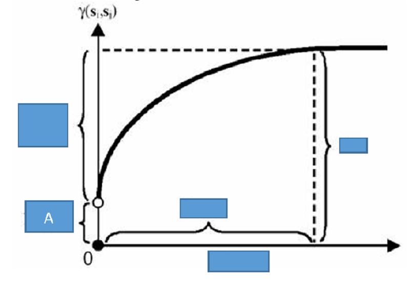
In the semevariogram like the one shown here, what is plotted on the x axis?
Nugget
Sill
Semivariance
Lag Distance
Which spatial interpolation method assumes that any point within a Voronoi polygon is closer to the polygon’s known point than any other known points?
IDW
Krigging
Thiessen Polygon
Spline
Density estimation technique can be applied to line data and estimate line density.
True
False
In a global interpolation technique, all the points in the data are used to estimate the values of locations for which data is unavailable.
True
False
Ordinary Krigging technique assumes that there is anisotropy (trend or drift) in the spatial data.
True
False
____ programing language is used in ArcGIS Pro to run a tool.
Forton
English
Python
C ++
In a model where logical expressions such as “&” “or” etc. Are used, the output raster cells will have index values.
True
False
Which of the following options can be used to run a tool in ArcGIS? (select all the options that you think are correct)
Tools in ArcToolBox
Python Script in ArcGIS
Model Builder
None of the above
In a turn table of a Network database, a turn of Minus (-) 90 degrees indicates ____
Left turn
Right turn
Overpass
No entry
In a Pure Network, the flow characteristics such as speed limits, one way etc. Are included
True
False
An example for the Link Impedance in a network analysis is --------
Street Name
Speed limit
Street network
Driver
In a turn table, -1 in a minute column indicates ___
Right turn
Left turn
U turn
No turn
A turn angle of 0 degree in a turn table of a network analaysis indicates___
Left turn
Go straight
U turn
Right turn
If the GIS model output shows the values: 0s and 1s, - it is a ______ model
Binary model
Index model
Vector model
Raster model
Four ways to run a ArcGIS Pro tool are using Python Script in ArcGIS Pro, ToolBoxes, a standalone Python script & ____
Model builder
Flowchart
Google Earth
Dataframe
The file extension of a ArcGIS Pro document is _
*.prj
*.shp
*.aprx
*.xls
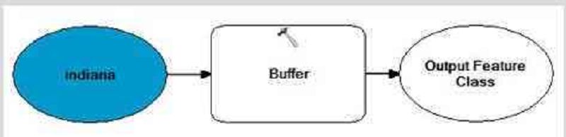
In the model builder, if the added tool is shown as the one below, that means______________
Ready to run
Not ready to run
Already run
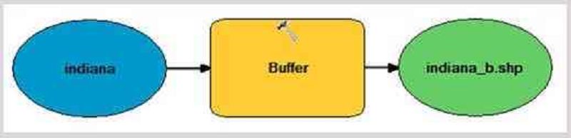
In the model builder, if the added tool is shown as the one below, that means______________
Ready to run
Not ready to run
Already run
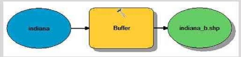
In the model builder, if the added tool is shown as the one below, that means______________
Ready to run
Not ready to run
Already run
Iteration tool in a Model Builder helps to do a process over and over using different settings or data.
True
False
{"name":"GIS Review", "url":"https://www.quiz-maker.com/QPREVIEW","txt":"Test your knowledge of Geographic Information Systems (GIS) with this comprehensive quiz designed for students and professionals alike. Dive into various topics including raster analysis, spatial statistics, and interpolation techniques.Highlights of the quiz include:30 thought-provoking questionsMultiple choice format for easy answeringImmediate feedback on your responses","img":"https:/images/course3.png"}