ERTH 365 Final Practice

ERTH 365 Final Practice Quiz
Test your knowledge with the ERTH 365 Final Practice Quiz! This comprehensive quiz features 30 multiple-choice questions, designed to prepare students for their final exam on weather systems and meteorology. Challenge yourself with questions that cover everything from pressure systems to scientific principles.
- In-depth coverage of meteorological concepts.
- Ideal for refreshing your knowledge before exams.
- Perfect for students and enthusiasts alike!
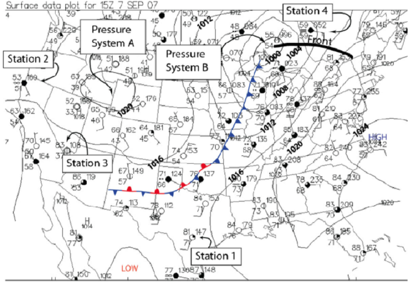
Pressure System A on the chart is a High Pressure area. This means
Dew points are high.
The air there is cold.
The air there is warm
The atmospheric pressure (weight) is greater there than in surrounding areas.
The atmospheric pressure (weight) is less there than in surrounding areas.

Pressure System B on the chart is a Low Pressure area. This means
Dew points are high.
The air there is cold.
The air there is warm
The atmospheric pressure (weight) is greater there than in surrounding areas.
The atmospheric pressure (weight) is less there than in surrounding areas.
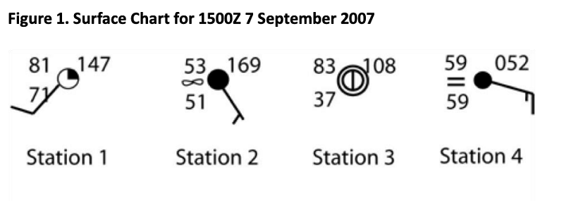
Station 4 is reporting
A thunderstorm
Heavy continuous rain
Moderate fog
Heavy continuous snow
Haze

The station(s) with a relative humidity of 100%
Station 1
Station 2
Station 3
Station 4
Stations 1,2 & 3

The station(s) with the lowest relative humidity
Station 1
Station 2
Station 3
Station 4
Stations 1,2 & 3

The pressure at Station 3 is
1080 mb
1010.8 mb
910.8 mb
520 mb
1052 mb

The FRONT shown on the weather map is
A stationary front
A cold front
A warm front
An occluded front
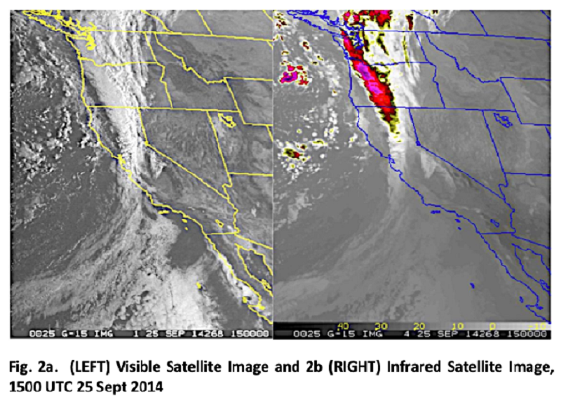
Which of the following explain why it is possible to see clouds on satellite photographs taken at night as shown in infrared satellite image, Fig. 2b?
The clouds reflect visible light from the sun
the clouds reflect light coming from the moon
The clouds emit visible light
The clouds emit infrared light/energy

With respect to the visible satellite image, Fig. 2a, the texture in the cloud band located over northern California is probably due to
Different cloud colors.
shadows cast by towering cloud-forms on the lower overcast.
Cold temperatures at 500 mb.
Unusually warm sea surface temperatures.
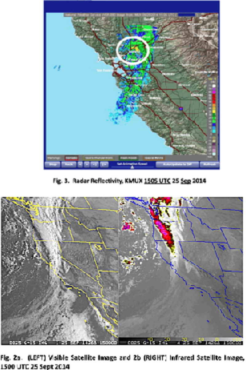
Fig. 2a and b and Fig. 3 in combination would suggest to meteorologists that
Fog is present in the Sacramento Valley.
Severe thunderstorms are occurring off the Southern California coast
Cold temperatures are over the Central Valley.
Dew points are very high over California.
A band of moderate to heavy precipitation is moving through northern California
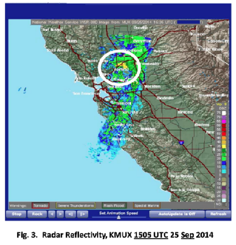
The information in Fig. 3 suggests that the precipitation near Fairfield (circled) is associated with
Stratus
Fog.
Cumulonimbus.
Cirrus.
Nimbostratus.

Figures 2a and b together suggest that the main immediate forecast issued for the Southern California coastal waters would be
Fog
Frost.
Warm temperatures.
low dew points.
Thunderstorms

The local time in San Francisco for the radar image is:
15:05 PDT
3:05 PM PDT
7:05 AM PDT
8:05 AM PDT
11:05 PM PDT
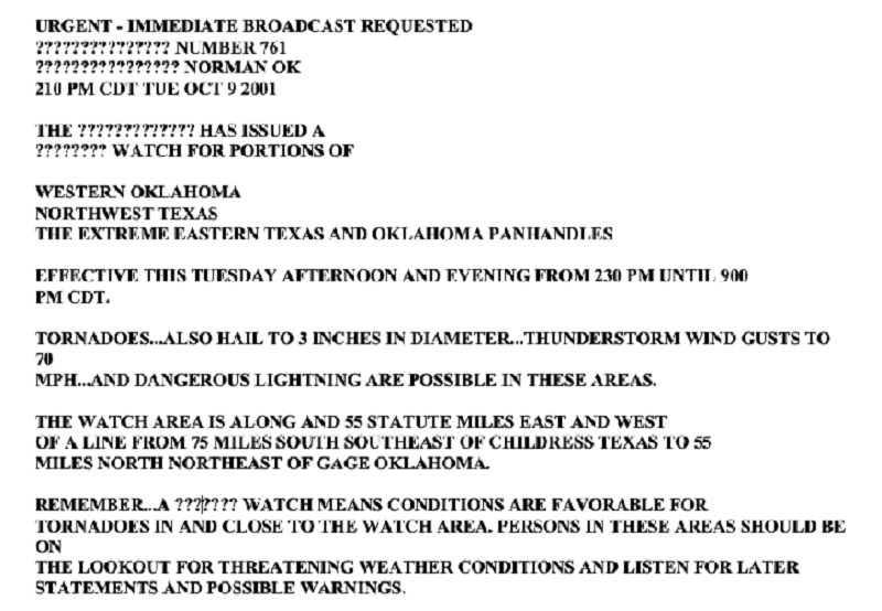
This text corresponds to:
A Tornado Warning
A Severe Thunderstorm Warning
A Hurricane Watch
A Tropical Storm Watch
A Tornado Watch
Which of the following is NOT included in the definition of a severe thunderstorm
Hail 1” or large
Straight line winds 57 mph or greater
Frequent cloud-to-ground lightning
Tornadoes
all of the above are part of the definition of severe thunderstorms
The definition for a Warning is
The given weather event is not expected to occur.
The given weather event is expected to occur sometime in the future, but no one can say when.
The given weather event is occurring, or is observed, and is about to move into the area mentioned in the statement. Take appropriate action immediately.
Conditions are favorable for the given weather event to occur in the time interval and for the area specified in the statement, although the weather event has not yet formed. Persons living in the area should listen for further statements and should take precautions in case the event occurs.
Is an advisory statement not meant to be taken literally.
The definition for a Watch is
The given weather event is not expected to occur.
The given weather event is expected to occur sometime in the future, but no one can say when.
The given weather event is occurring, or is observed, and is about to move into the area mentioned in the statement. Take appropriate action immediately.
conditions are favorable for the given weather event to occur in the time interval and for the area specified in the statement, although the weather event has not yet formed. Persons living in the area should listen for further statements and should take precautions in case the event occurs.
Is an advisory statement not meant to be taken literally.
Thunderstorms are associated with
cirrus clouds
Status clouds
Nimbostratus clouds
Cumulonimbus clouds
Altocumulus clouds
Severe thunderstorm forecasters often look at surface dew point temperatures to make a first guess of the region expected to get strong to severe thunderstorms. The minimum summertime surface dew point temperature they look for is
30°F
40°F
50°F
60°F
70°F
Cumulonimbus clouds show up very well on infrared satellite images because
their tops are very cold, and usually are evidenced in the primary colors on color infrared satellite images.
Their tops are very warm, and usually are evidenced in the primary colors on color infrared satellite images.
On such images rainfall is directly indicated in primary colors
Lightning is easily detected by the infrared satellite sensor.
infrared satellite images only show cumulonimbus clouds.
The scale used by meteorologists to rate tornadoes is known as
The Fujita Scale.
the Saffir-Simpson Scale.
The Dorothy Scale.
The Enhanced Fujita Scale.
The Doppler Scale.
The scale used by meteorologists to categorize hurricanes is known as
The Fujita Scale.
The Saffir-Simpson Scale.
The Dorothy Scale.
The Enhanced Fujita Scale.
The Doppler Scale.
The Scientific Method is
Only used in the United States.
Based upon a belief system.
Varies from country to country.
A series of structured steps that provide scientists with a blueprint of how to study and solve problems of the natural world.
None of the above.
Once the observations are made, or the data is collected, and the scientist observes some sort of systematic organization or pattern to the data, he or she develops an educated explanation for the pattern. This educated explanation is known as
A guess
An opinion
A theory
A flip of the coin.
A hypothesis
Once a theory is formulated it is tested. If the theory bears out statistically, it becomes a hypothesis
True
False
The example that Zebrowski and we have used (in class) to illustrate how to use a scientific PRINCIPLE to explain a pattern of observations of wind is that gases tend to move from high to low pressure areas.
True
False
For scientific research to be accepted in the scientific world, research papers that have undergone all the steps of the scientific method should be peer-reviewed.
True
False
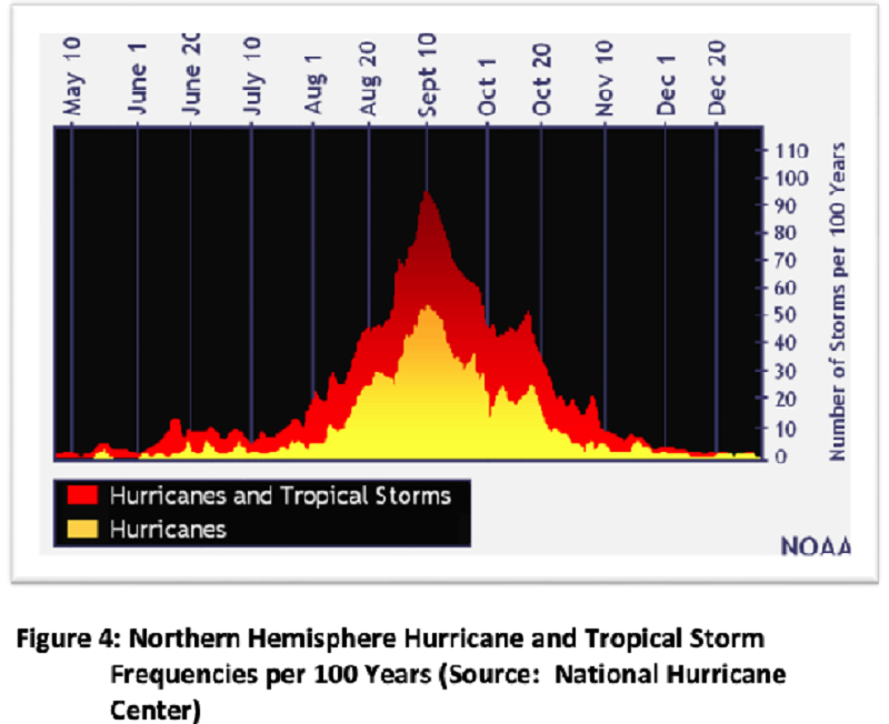
A logical hypothesis to explain the fact that tropical cyclone frequencies increase rapidly in the summer is (as shown in Figure 4 above)
that sea surface temperatures in the hurricane formation areas of the Northern Hemisphere have exceeded the minimum threshold that supports such storms at that time.
That the polar jet stream is very active at that time.
That the temperatures in tropical latitudes are still cold at that time.
that the dew points are unusually low at that time
That cold fronts are very active in tropical latitudes at that time.
The minimum sea surface temperature that seems to support the intensification of tropical cyclones is
28°F
28°K
16°C
61°F
28°C
The general tracks of hurricanes in the Atlantic extend from east to west with most hurricanes curving northward back towards the eastern portion of the Atlantic Ocean.
True
False
The Coriolis force is the main reason hurricanes curve northwards in the Northern Hemisphere
True
False
�A tropical cyclone in which the maximum sustained surface wind speed (using the U.S. 1- minute average) ranges from 34 kt (39 mph or 63 km/hr) to 63 kt (73 mph or 118 km/hr) and with usually associated with at least one isobar surrounding the area of lowest pressure at sea-level.”
Is the definition of a tropical low.
is the definition of a tropical depression.
is the definition of a tropical storm.
Is the definition of an easterly wave.
Is the definition of a hurricane.
Most of our “weather” occurs in the_________.
Exosphere
mesosphere
Troposphere
Stratosphere
Air pressure always _________ and air density always ________ as we climb upward in the atmosphere?
Decreases, decreases
Decreases, increases
Increases, decreases
increases, increases
Approximately at what altitude is the “middle” of the atmosphere, where half the air molecules would be above you and half below?
10,000 feet (700 millibars)
18,000 feet (500 millibars)
30,000 feet (300 millibars)
39,000 feet (200 millibars)
Pressure changes ________
More rapidly in the horizontal direction than in the vertical.
More rapidly in the vertical direction than in the horizontal.
At the same rate in the horizontal and vertical directions.
More rapidly in the vertical over land than over the ocean.
Air flows from higher pressure toward lower pressure _________________
At all places on earth.
Only at the equator.
Only in the Northern Hemisphere.
Only in the Southern Hemisphere.
Both local and global wind systems are ultimately the result of __________.
Differential heating
Differences in gravity
Global warming
More land mass in the Northern Hemisphere
Which of the statements below is not correct concerning the pressure gradient force (PGF)?
The PGF points from high to low pressure in the Northern Hemisphere
It is non-existent at the equator
it can cause the wind to speed up or slow down
The PGF points from high to low pressure in the Southern Hemisphere
A wind blowing at a constant speed parallel to straight isobars, with the pressure gradient force (PGF) and the Coriolis force in balance is called a ________
Gradient wind.
Meridional wind.
Geostrophic wind.
Cyclostrophic wind.
A wind blowing at a constant speed parallel to curved isobars, with the pressure gradient force (PGF) and the Coriolis force in balance is called a ________
Gradient wind.
Meridional wind.
Geostrophic wind.
Cyclostrophic wind.
Developing low pressure areas (i.e., cyclogenesis) generally have ________ air near the surface and _______ air aloft.
Converging, diverging
Diverging, converging
Converging, converging
Diverging, diverging
Friction at the Earth’s surface causes the wind to ________
Cross the isobars towards the center of a low pressure.
cross the isobars towards the center of a high pressure.
Speeds the wind up.
All of the above
In the three-cell model of the general global circulation, areas of surface low pressure should be found at ________
The equator and the poles.
The equator and 30° latitude.
The equator and 60° latitude.
30° latitude and 60° latitude.
Many of the world's deserts are found near 30° latitude because ________
The inter-tropical convergence zone (ITCZ) is located there.
Of sinking air found near the polar front.
Of the convergence of the prevailing westerlies and the Northeast Trades
Of the sinking air of the sub-tropical highs.
What is a reasonable barometric pressure reading for San Francisco?
10 millibars
100 millibars
1000 millibars
2000 millibars
The four main cloud groups are ________
low, middle, high and vertical growth clouds;
Cirrus, cirrostratus, cirrocumulus and cirrus congestus;
altostratus, altocumulus, altomammatus and lenticularis
Cumulus, cumulus congestus, cumulonimbus and nimbostratus.
Halos around the sun are typically caused by ________ clouds:
Altostratus;
Nimbostratus;
stratus;
Cirrostratus;
Fog is made up of ________ clouds:
Altostratus;
Nimbostratus;
Stratus;
Cirrostratus;
Cumulonimbus clouds generally grow from cumulus clouds
True
False
El Niño / La Niña are
atmospheric related events
Ocean and atmospheric events
Annual global events
Ocean related events
During an El Niño event, sea surface temperatures (SSTs) are ____________
Colder than normal along the California coast
Colder than normal in the eastern tropical Pacific
Warmer than normal in the eastern tropical Pacific
Warmer than normal in the western tropical Pacific
Which of the following are El Niño myths?
El Niño is coming to California
All El Niños are the same
El Niño Storm due to strike California
El Niño means lots of rain for California
All the above
A cold front is a
Boundary with warmer (less dense) air behind it and colder (more dense) ahead of it
Boundary between the moist and dry air below a thunderstorm
Boundary with colder (more dense) air behind it and warmer (less dense) ahead of it
None of the above
Developing low pressure areas (i.e., cyclogenesis) generally have_____ air near the surface and_______ air aloft.
Diverging, converging
Converging, converging
Diverging, diverging
Converging, diverging
Which is NOT true about a developing/intensifying mid-latitude/wave cyclone?
Air sinks in the center of the dynamic low pressure center
It is a dynamic low that intensifies with height
Upper-level divergence is stronger than surface convergence
It is a cold core low pressure system
The typical life-time of a mid-latitude wave cyclone is _____________ days.
3
4
5
6
The Jetstream is
The vapor trail that comes out of an airplane engine at high altitudes
The fast flowing “river” of air in the upper atmosphere
The latest Dreamliner aircraft from Boeing
A fast-flowing surface wind that blows from the Atlantic towards the East Coast in winter
An Atmospheric River is
. An approximately 250-375mile wide concentration of water vapor in the atmosphere
An approximately 250-375mile wide strong wind in the lower atmosphere
An approximately 250-375mile wide strong wind in the upper atmosphere
All the above
Just a few atmospheric rivers generally
. Account for 30-50% of the annual precipitation on the US East Coast
Account for 30-50% of the annual precipitation on the US West Coast
The latest Dreamliner aircraft from Boeing
A fast-flowing surface wind that blows from the Atlantic towards the East Coast in winter
Condensation is a warming process and the heat liberated is called _____________ .
Adiabatic heat
Heat of Condensation
Latent heat
Radiation heat
California’s coastal summer advection fog is a result of ____________ cooling?
Convectional
Expansion
Conductional
Conservative
Cold-core low pressure systems
Have rising air in all levels of the atmosphere
Tilt to the northwest with height
Have the coldest temperatures at the center of the low
All the above
Over the past 100 years or so, it appears that average global temperatures have:
Decreased slightly
Fluctuated wildly but shown no overall change
. Increased slightly
Remained constant
Since the early 1900’s, carbon dioxide (CO2) in the atmosphere has _____________ .
Been increasing in concentration
Been decreasing in concentration
Disappeared entirely
. Remained at about the same concentration from year to year
Which of the following has been used to reconstruct past climates?
Analysis of air bubbles trapped in ice
. Study of documents describing floods, droughts and crop yields
. The ratio of oxygen 18 to oxygen 16 in the shells of marine organisms
All of the above
A lapse rate best describes a ______________.
Change of pressure with height
Change of temperature with height
change of water vapor with height
change of temperature over a horizontal distance
An adiabatic process occurs when there is no heat exchange between a parcel of air and the air outside of the parce
False
True
Moist air cools at a faster rate when moving up in the atmosphere compared to dry air.
True
False
If a parcel of air is given a small upward push and it continues upward, the parcel is considered to be ______________.
Releasing latent heat of evaporation
causing precipitation
Unstable
Stable

The letter A locates the
Eye of the storm.
Eyewall
High pressure area at the top of the storm.
Divergence at the top of the storm.
Hurricane's spiral rainfall bands.

The letter B locates the
Eye of the storm.
Eyewall
High pressure area at the top of the storm.
Divergence at the top of the storm.
Hurricane's spiral rainfall bands.
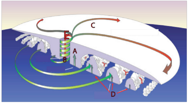
The letter C locates the
Eye of the storm.
Eyewall
High pressure area at the top of the storm.
Divergence at the top of the storm.
Hurricane's spiral rainfall bands.

The letter D locates the
Eye of the storm.
Eyewall
High pressure area at the top of the storm.
Divergence at the top of the storm.
Hurricane's spiral rainfall bands.

The letter E locates the
The warmest cloud tops
Eyewall
The area with the greatest storm surge.
High pressure area and Divergence at the top of the storm
Hurricane's spiral rainfall bands

The strongest thunderstorms would likely be found at Location
A
B
C
D
E
The storm surge is strongest in the right front quadrant of the progressing hurricane. It is in this region that
Divergence is the greatest
Thunderstorms are the most severe.
The effects of low pressure at the eye, forward motion of the storm and strong winds locally force unusually high ocean levels, relative to sea level, are combined.
The eyewall is found
Ocean temperatures are the warmest.
The eye of the hurricane forms because
The lowest surface pressures are found at the center of the storm.
It is the area in which the strongest thunderstorms are found.
The atmosphere is very unstable there.
Air circling into the storm center is moving so quickly inward and upward, that centrifugal force prevents it from reaching the center of the low. Air from the high troposphere and low stratosphere sinks to the surface, thus creating a relatively clear, windless area at the center of the storm.
The effects of low pressure at the eye, forward motion of the storm and strong winds locally force unusually high ocean levels, relative to sea level are combined.
Although tropical cyclones form when clusters of thunderstorms move over ocean temperatures greater than 82°F, the chief reason for intensification of these disturbances to hurricanes is
Strong jet stream level winds.
Downdrafts from thunderstorms
Coriolis effect.
Convergence in the upper troposphere
The tremendous release of latent heat when the air with very high dewpoint temperatures over the ocean is ingested into the circulation of the developing storm.
The chief threat from tropical cyclones once they pass far inland is associated with
Storm surge
Flash flood producing rainfall and severe thunderstorms
The Coriolis effect.
Strong winds.
Tornadoes
You live along the Atlantic seaboard. A hurricane warning is issued for your area. You should
Get into an interior room.
Evacuate the coast and move inland.
Hide in a storm shelter
Board up your windows and get into the bathtub.
Go to the beach and watch for the storm surge.
A tropical storm is
Any member of the hurricane family.
A tropical cyclone with winds between 39 and 74 mph
A decaying tropical depression
A storm of hurricane strength
A typhoon
A hurricane is
A. A severe tropical cyclone
B. A tropical cyclone with winds of 65 knots (74 mph) or greater
C. A tropical cyclone with tornadic thunderstorms embedded in it
D. The same as a typhoon
B. and D.
Hurricanes in the Northern Hemisphere tend to move westward because
Of the Coriolis Effect.
Nature does not like vacuums
They are "attracted" to warm water.
Pressures are lower in the west.
Hey form at the latitude of the prevailing easterlies at the surface (called the northeast trade winds).
The most significant source of heating leading to hurricane formation (besides warm ocean temperatures) is
Strong solar insolation
The release of latent heat from condensing water vapor
Divergence at the top of the storm
Friction
Lightning heating up the air
A tornado-like event that forms over water is a __________ .
Mesohigh
Microburst
Waterspout
Roll cloud
A line of thunderstorms that forms ahead of an advancing cold front is called a _____ .
gust front
Squall line
. Roll cloud
Wall cloud
A discharge of electricity from or within a thunderstorm is called _________ .
An atmospheric arc
a downburst
Lightning
. St. Elmo's fire
Thunder is caused by ________________________.
Angels bowling
The collision between two thunderstorms with opposite electrical charge
The explosion when + and - charge collide and neutralize each other
The rapid heating of the air surrounding a lightning channel
If you see a lightning stroke and then 10 seconds later you hear the thunder, the lightning is about __________ away.
1 mile
2 miles
10 miles
20 miles
The Enhanced Fujita scale pertains to the _______________________________ .
Amount of hail that falls from a mature thunderstorm
Size of the thunderstorm image on a radar screen
Size of a tornado producing supercell
. Strength and destructive force of a tornado
The "Tornado Alley" region of the United States is located ____________ .
In Florida
in the Ohio Valley
In the Central Plains
In the mid-Atlantic states
Most tornadoes in the U.S. Move from the ____________________ .
Southeast to northwest
Southwest to northeast
North to south
northwest to southwest
Which is NOT a thunderstorm hazard?
Flash floods
Hail
Downbursts
Low humidity
Thunderstorms are most enhanced by ____________________ .
Strong pressure gradient force
Cool dry air at the surface
Strong diverging winds aloft (upper levels)
Very little or no vertical wind shear
Which is not a thunderstorm type?
Airmass thunderstorm
. Cumulus thunderstorm
Supercell thunderstorm
Severe thunderstorm
A Mesoscale Convective System (MCS) is actually one very large thunderstorm.
True
False
What is the most destructive category of a tornado on the Enhanced Fujita scale?
EF0
EF10
EF5
EF4
Tornadoes generally form from what type of cloud?
Supercell cumulonimbus
Super nimbus
Cumulus humilis
Super stratus
In general, a mesocyclone precedes a tornado by _____________ minutes?
5
50
10
30
{"name":"ERTH 365 Final Practice", "url":"https://www.quiz-maker.com/QPREVIEW","txt":"Test your knowledge with the ERTH 365 Final Practice Quiz! This comprehensive quiz features 30 multiple-choice questions, designed to prepare students for their final exam on weather systems and meteorology. Challenge yourself with questions that cover everything from pressure systems to scientific principles.In-depth coverage of meteorological concepts.Ideal for refreshing your knowledge before exams.Perfect for students and enthusiasts alike!","img":"https:/images/course7.png"}
More Quizzes
Explore the Science of Climatology
10528
Meteorological Mastery Quiz
65320
Golf Course or Mega Church?
37180
Music Terminology (A)
1160
Discover Your Best Poodle Cross Match - Free
201025618
What Does SHD Mean in Texting? Free Texting Skills
201025162
Condensed Matter Physics I
15833307
Free Scientific Notation Exam & Practice
201023712
Who Moved My Cheese Characters: Which One Are You?
201024941
Consistency of Tenses: Master Verb Consistency
201027957
Test Your Dionysus Parents Knowledge - Greek God
201041177
Master French Moods: pouvoir Subjunctive Conjugation
201032454