Georgia regions quiz: Name the five geographic regions of Georgia
Quick Georgia geography quiz to test what you know. Instant results and review.
This quiz helps you name Georgia's five geographic regions and check what you remember. After you finish, keep exploring U.S. places with our American geography quiz or focus on the Southeast in a quick southeast states and capitals quiz. Studying for class? Brush up with friendly 5th grade geography questions and see how your skills compare.
Study Outcomes
- Identify the Five Geographical Regions of GA -
After completing the quiz, readers will be able to accurately list the five geographical regions of GA and pinpoint their relative locations on a state map.
- Describe Key Characteristics -
Readers will learn to describe defining features of each region, including landscape, soils, and vegetation, as they relate to Georgia's diverse geography.
- Compare Regional Differences -
Participants will be able to compare and contrast the climate, elevation, and natural resources across Georgia's five geographic regions.
- Recall Region-Specific Facts -
Users will enhance their ability to recall important trivia and landmarks tied to each region, improving performance on geography of Georgia questions.
- Apply Knowledge in a Quiz Setting -
By engaging with the Georgia geographic regions quiz, readers will practice listing and explaining the regions under time pressure.
- Understand Regional Impact -
Readers will gain insight into how Georgia's land regions influence its culture, economy, and environmental planning.
Cheat Sheet
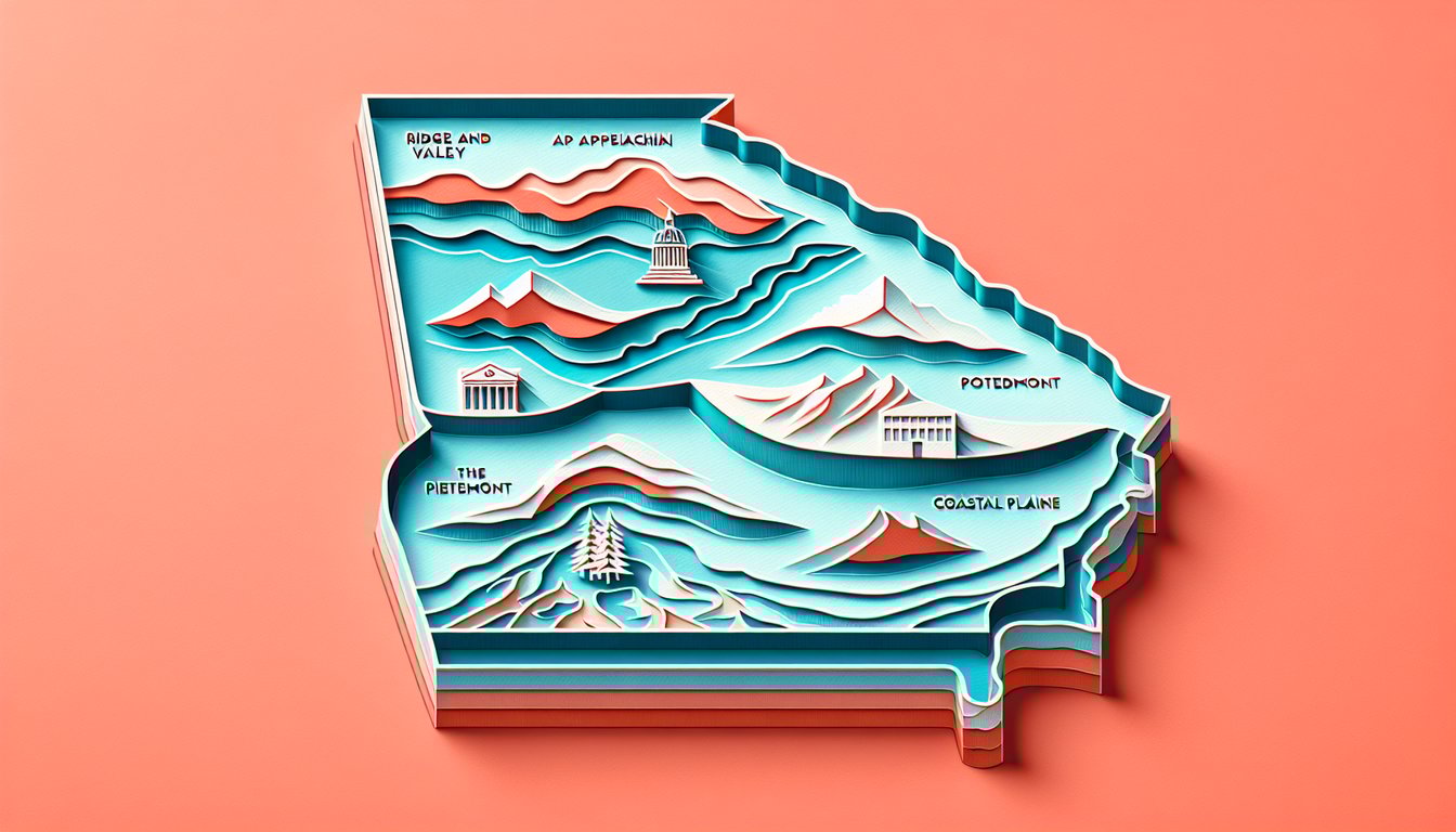
- Appalachian Plateau -
This tiny region in northwest Georgia features sandstone cliffs and coal seams, notably at Lookout Mountain, making it the highest plateau in the state (UGA Extension). Its western edge drops sharply into the Cumberland Escarpment, providing dramatic elevation changes studied by the USGS. Remember, it's the "cap" that sits above the folded Ridge and Valley region.
- Ridge and Valley -
Characterized by parallel ridges of sandstone and limestone valleys, this region supports the carpet and textile industries centered around Dalton (Georgia.gov). Geologists from the University of Georgia explain its folded structure formed during the Appalachian orogeny. The alternating ridges and valleys create a distinctive "accordion" landscape.
- Blue Ridge -
Home to Brasstown Bald, Georgia's highest point at 4,784 feet, the Blue Ridge boasts rich biodiversity and ancient crystalline rock (National Park Service). Its steep slopes feed major rivers like the Chattahoochee, vital for Atlanta's water supply. Hikers often use the mnemonic "Blue Balds Bring Beauty" to recall this lush, mountainous region.
- Piedmont -
As Georgia's largest region, the Piedmont consists of rolling hills underlain by granite and gneiss, hosting Atlanta and major tech hubs (UGA Geosciences). Soils here are red clay, ideal for vineyards and livestock, making it an agricultural as well as urban center. The Fall Line marks its boundary, a key geological shift noted by coastal and inland surveys.
- Coastal Plain -
Stretching from the Fall Line to the Atlantic, the Coastal Plain splits into inner (farmland, Okefenokee Swamp) and outer zones (barrier islands, salt marshes) according to Georgia.gov. It's Georgia's breadbasket for peanuts and cotton, benefiting from sandy, well-drained soils. A handy mnemonic - "A Really Big Pie, Completely" (Appalachian, Ridge & Valley, Blue Ridge, Piedmont, Coastal) - helps you list the five geographic regions of Georgia with ease.